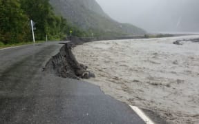
The violent weather which has buffeted the country today is expected to last into Friday morning.
MetService said the major storm (former tropical Cyclone Fehi) was moving south-east across the South Island through Thursday and would move away on Friday morning. The storm would continue to bring significant heavy rain and damaging winds to much of the South Island and parts of the North Island during this time.
Here's the MetService's summary of what to expect:
Bay of Plenty, Rotorua, and the Gisborne ranges till 6am Friday.
Rain, with heavy falls till Friday morning. Expect 100 to 150mm, mainly about the ranges. Peak intensities of 20 to 40mm per hour with thundery downpours possible.
Waikato, Waitomo, Taumarunui, Taupo, and Taihape till early Friday
Rain with heavy falls easing Friday morning. Expect 80 to 130mm, mainly about the ranges. Peak intensities of 20 to 40mm per hour with thundery downpours possible.
Mt Taranaki until early Friday
Periods of heavy rain. Expect 80 to 130mm. Peak intensities 25 to 35mm per hour.
In 12 hours:
— MetService (@MetService) February 1, 2018
Westland ranges +200mm
Mt Cook Airport 126mm
The West Coast Glaciers around 125mm
Milford Sounds 112mm
Dunedin City 101mm
Arthurs Pass 91mm
More information at https://t.co/Yjbq0jxdqz ^Lisa pic.twitter.com/QUYsXRCeia
Marlborough, Nelson and Buller
Periods of heavy rain from early Thursday morning to evening. Expect a further 80 to 120mm, especially about the ranges, in addition to what has already fallen. Peak intensities 25 to 35mm per hour.
Tararua Range till early Friday
Periods of heavy rain. Expect 100 to 150mm, with peak intensities of 20 to 30mm per hour.
Westland till 6am on Friday
Rain with heavy falls. Expect a further 200 to 350mm - or possibly even more - to accumulate south of Otira, and 170 to 200mm farther north, especially about the ranges. Peak intensities 30 to 40mm per hour, in thundery downpours. Note, the combination of strong winds, large swells and high tides may cause inundation about the coast.
Canterbury High Country within 20km east of the divide till 8am Friday
Heavy rain is forecast. Expect a further 120 to 160mm, but 200 to 250mm near the divide. Peak intensities 15 to 25mm per hour.
Fiordland till early Friday
Expect a further 180 to 250mm north of Doubtful Sound and 120 to 200mm farther south. Peak intensities of 25 to 40mm per hour in thundery downpours.
Otago till early Friday
Heavy rain is forecast to ease early Friday. Expect a further 80 to 150mm - possibly even more in the west - but 50 to 80mm about North Otago. Peak intensities 15 to 30mm per hour.
Southland till late Thursday
Expect 50 to 90mm of rain to accumulate. Peak intensities 10 to 25mm per hour.
[http://www.radionz.co.nz/news/national/349391/live-state-of-emergency-declared-in-dunedin-as-flooding-spreadsFor more updates of the wild weather follow our live blog.]