Multiple regions have delcared a state of emergency as Cyclone Gita bears down on New Zealand tonight.
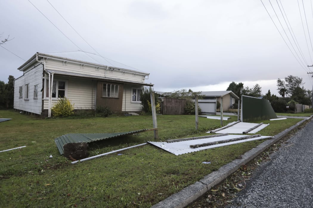
Broken fence on Brougham St in Westport Photo: RNZ / Rebekah Parsons-King
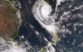
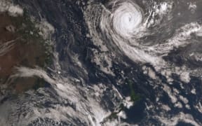
MetService says the eye of the storm has hit landfall and is now hovering over the western tip of the South Island.
Over the next few hours it's expected to move south-east, settling over the South Island's upper east coast tomorrow morning.
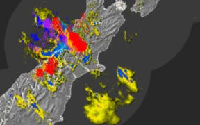
It forecasts more heavy rain overnight and into the morning for the Kaikoura Coast, Canterbury, and eastern Otago.
There will be gale force winds gusts for the upper South and lower North Islands, but these will ease tomorrow.
These winds will cause large waves bigger than six metres high, which threaten to inundate much of the coast from Raglan to Wellington in the North Island, and everywhere north of Buller in the South.
However, MetService says the very worst of the weather is likely over, and conditions are expected to ease as Gita moves away on Wednesday.
Civil Defence has warned people in the firing line to be ready for power cuts, road closures and evacuations.
A state of emergency has now been declared in the Taranaki region, in addition to Christchurch, Buller, Grey District, Selwyn District, Westland District and the Nelson Tasman region.
Nearly 200 schools and pre-schools nationwide are closed, with more than 20,000 students affected.
The storm caused havoc in the Pacific where, at times, it measured category five, the highest possible.
It flattened and flooded homes and business, and knocked out power and communications in Tonga, Samoa and some Fiji islands.
Prime Minister Jacinda Ardern said Defence Force personnel have been deployed to the areas expected to be hardest hit.
- Check the latest information in our live blog
- Get the full picture with our wrap-up of the day's events
Check out MetService's latest forecast here
Here is what you need to know:
How to prepare
- Discuss with your household - family, flatmates, whatever your living situation - what to do if you need to evacuate your home, or the power or water goes out.
- Prepare a grab bag in case you need to get out quickly.
- Make sure you know where you pets are and be ready to take them with you.
- Secure outdoor furniture, rubbish bins, trampolines.
- During the storm keep windows and doors closed, and close curtains to increase safety in case windows blow out or break.
- Check NZTA for travel information
- Over 40 schools and 17 early childhood learning centres at the top of the South Island are closed today
Nelson, Buller and West Coast
- A state of emergency has been declared in Buller by mayor Garry Howard.
- A state of emergency has also been declared in the Nelson Tasman region.
- Civil defence says heavy rain is expected in Takaka which will lead to more flooding, including in Takaka township.
- Up to 200mm rain within 14 hours from 7am to 9pm Tuesday, peak intensities 20mm/h to 30mm/h.
- Severe gale east to northeast winds with damaging gusts of 140 km/h in exposed places.
- Residents told to prepare emergency kits and evacuation plans.
- Air New Zealand has cancelled all flights in and out of Nelson Airport from midday.
- Stockton Mine near Westport, which employs 230 people, has been evacuated as a precaution.
- Westland District Council activated its Emergency Operations Centre this morning at 11am, council staff are preparing for the storm to hit the area from 1pm.
- Westland and Canterbury High Country: Severe gale southeast winds with damaging 150km/h gusts in exposed places between midday Tuesday and 1am Wednesday.
- All schools and early childhood centres in the Buller District closed today and Wednesday as a precaution.
- Air New Zealand has cancelled all flights to and from Hokitika
- A Civil Defence app has sent an alert to 2000 campers on the West Coast warning them to prepare. Hotels are also warning tourists to prepare.
- Port of Westport closed until further notice.
Marlborough including Kaikōura coast
- 150mm to 200mm rain at higher ground between 7am and 10pm Tuesday. Peak intensities 20mm/h to 30mm/h.
- SH1 north and south of Kaikōura closed
- Severe gale southeasterlies gusting 120 km/h in exposed places.
- Campers, trampers and boaties warned to leave the Marlborough Sounds today.
- Civil Defence suggests residents in low-lying coastal areas consider staying elsewhere tonight.
Wellington and Kāpiti Coast
- A number of flights into Wellington Airport have been cancelled this morning. Most flights are scheduled to start operating again after 7am.
- NZTA is urging drivers to delay travel tonight as heavy rain and strong winds hit the bottom of the North Island.
- Wellington's City Council is asking residents to wait until morning to put out their rubbish for collection, as strong winds are expected this evening into tonight.
- Northerly winds forecast to peak up to 140km/h at Titahi Bay about 9.30pm.
- 75mm to 100mm rain between 1am and 4pm Tuesday. Peak intensities 20mm/h to 30mm/h. Further light rain until midnight.
- Air New Zealand has cancelled all flights in and out of Wellington airport from 2.45pm until midnight.
Taranaki
- A state of emergency was delcared in the Taranaki region at 7.50pm.
- Nearly 23,000 properties were without power at 6.20pm.
- No Air New Zealand flights in and our of New Plymouth airport.
- Wind gusts of up to 140km/h in exposed areas in southern Taranaki.
- Civil Defence in Taranaki is advising people to fill their cars with petrol and prepare emergency packs in case the area is hit with full force.
Transport
- People are being told to check ferry sailings as the cyclone track is likely to pass through Cook Strait, bringing large waves.
- KiwiRail has cancelled the TranzAlpine train today and will review the service for Wednesday.
- Air New Zealand is warning travellers to expect significant disruption to domestic flights.
- MetService has warned of large waves up to 6m with a combination of tides, low pressure, strong onshore winds.
- The Transport Agency says Cyclone Gita will make driving conditions treacherous and motorists should avoid all unnecessary travel.
- Slips and coastal flooding may mean roads are closed at short notice.
- High winds could also make conditions hazardous for motorcyclists, campervans and other high-sided vehicles, the Transport Agency said.
- Maritime NZ is broadcasting live storm warnings on VHF safety channels 67, 68 and 71.
Christchurch
- The Christchurch City Council is asking residents to temporarily reduce their water use, with Cyclone Gita putting pressure on the city's wastewater system.
- The Selwyn District Council has declared a State of Emergency.
- Heavy rain watch upgraded to a warning.
- More than 70mm of rain in 24hrs, could cause street flooding.
- Higher rainfall expected in Banks Peninsula.
- Winds of 70km/h or greater expected.
- People living in areas prone to flooding are encouraged to lift valuable possessions off low-lying floors and to park their cars on higher ground.
- Check the city council website for updates.
Queenstown
- No Air New Zealand flights to and from Queenstown airport