Engineers will use ground-penetrating radar to assess the area surrounding a massive sinkhole that has closed campgrounds at Inskip Point near Fraser Island in south-east Queensland.
A sinkhole swallowed vehicles at a campsite near Queensland's Rainbow Beach. Photo: AAP / Higgins Storm Chasing
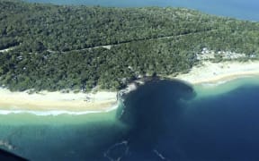
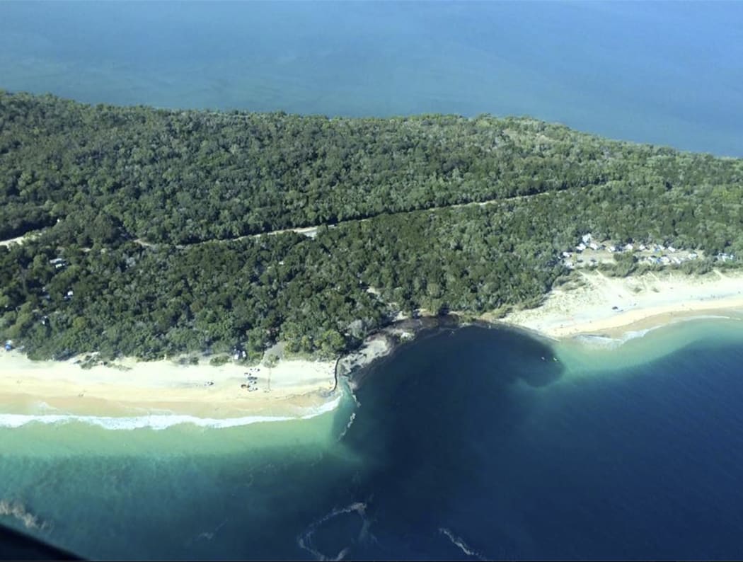
The sinkhole claimed 200 metres of beachfront and about 50 metres of a popular campground and swallowed up a caravan, four-wheel drive camper-trailer and tents late Saturday night.
No-one was injured, but more than 300 holidaymakers have been forced to leave the area.
However, six campgrounds still remain open on the peninsula.
Senior ranger Daniel Clifton said the campsites on either side of the sinkhole would remain closed until geotechnical engineers assessed the area using ground-penetrating radar.
"Our ultimate concern is about the safety of the visitors," he said.
"Until we get more information we're not really sure about the stability of the site so we're just being a bit precautionary."
Geotechnical engineer Allison Golsby said a series of tests would be conducted to check the area's stability.
"They [need to] do some analysis - use some geoscientific tools to test and see if there is a larger instability or a larger cavity underneath that area to know if it is going to get any bigger or not," she said.
"There are many reasons that this could occur, but there appears to be elements of a slip or slump failure here, rather than just a sinkhole-type behaviour.
"That's maybe when geotech engineers need to go and have a look at it and make sure what's happening.
"Slips and slumps are usually formed through very loose material that is either saturated or semi- saturated with water, water movement, getting to a point where they become unstable and they fall away because they can't be supported by whatever is underneath them or at their base."
Ms Golsby said a monitoring system in the area could provide early warnings.
"This area has a history where sinkholes occur regularly - the ideal answer is... to monitor because then we keep everybody in the right place and they won't be put in a position like that," she said.
"It depends on what type of systems can be put in place and if there is actually any consistent behaviours that are occurring before any of these falls or failures occur.
"If that can be discovered, it is a little bit like volcanoes and earthquakes, we need to also find what those behaviours are.
"If we can pick up what changes are occurring, when there is likely to be one, and then how do we get the information to the people who are most interested, and that will be the people going and visiting the area."
She said that geoscientists had ruled out recent earthquake activity in southern Queensland as the cause of the sinkhole.
Ms Golsby said earthquakes could cause sinkholes but not in this instance.
"This area has a history where sinkholes occur regularly, it is something to do with the way sediments are formed and the way water moves through the Earth over millions of years or thousands of years," Ms Golsby said.
"Sinkholes are basically those cavities coming to the surface.
"An earthquake can trigger a sinkhole from a cavity but it has to basically happen on the day or in a very close time frame to the earthquake. In this case I don't see the link."
- ABC