
By Alison Ballance
Archaeologist Bruce McFadgen hopes that peat being dug up during large-scale road works will provide key pieces to the puzzle of historic Maori occupation along the Kapiti Coast – but so far all the peat has revealed is a new puzzle, in the form of a thick layer of pumice, which may – or may not – be evidence of a tsunami.
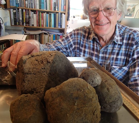
Archaeologist Bruce McFadgen with some of the pumice found in a thick layer in peat on the Kapiti Coast, which varies in size from 2 mm to 30 cm. Photo: RNZ / Alison Ballance
Tsunamis are devilish difficult things to identify. We can have events that we know happened, yet they leave virtually no signature at all.
“Maori occupied [the Kapiti] coast and in the early period their settlements were very close to the sea,” says Bruce. “They were small hamlets with the odd house, flaking floor, shell midden, ovens, that sort of thing, where people had lived for a reasonable time. But in the later period that coastal occupation seems to have been abandoned and they settled along the rivers. So something was going on about 4-500 years ago that we would dearly like to know more about.”
Peat forms from partly decayed wetland vegetation that accumulates in wet, low oxygen conditions.
“Peat is a record of things like vegetation change,” says Bruce. “Sand dune movements, for example if sand has blown inland and got into the peat then we can see that. It may give us information about tsunamis … and uplift and subsidence, and what’s been going on seismically up and down that coast.”
Bruce McFadgen is an Honorary Research Associate in the School of Maori Studies at Victoria University of Wellington. His interest in the peat being exposed during the construction of the MacKays to Peka Peka highway on the Kapiti Coast follows a lifetime of archaeological research up and down the nearby coast. During that time he’s been collecting pieces of information that variously suggest that subsidence of the ground, or conversely uplift of the land, or the build-up of sand dunes might have been responsible for changing patterns of vegetation and Maori settlement seen over 600 or so years.
At an early archaeological site in coastal Manawatu he recorded a dryland ecosystem suddenly becoming a wetland, coinciding with the abandonment of a Maori settlement there. For about 50 years he thought that the sudden rise in the water table might have been a result of sand dunes building up nearby and blocking the drainage.
The discovery five years ago of about 100 large tree stumps on a farm at nearby Te Horo added a supporting piece of evidence to this idea, as the date when the forest there died and was replaced by a wetland because of rising water levels matched the date of the Manawatu site.
However, the discovery a couple of years ago of a series of old shore lines at Peka Peka raised the new possibility that instead of the water rising to meet the land, the land itself had subsided. This idea was supported by further evidence around Pauatahanui Inlet to the south, and a pattern of old shorelines south of the Otaki River.
So, what Bruce is hoping is that the peat might hold some more significant pieces of this puzzle. He is working with a group of Honorary Research Associates in the School of Geography, Environment and Earth Sciences at Victoria University of Wellington, who are each bringing a particular skill to the project. Margaret Harper is a world expert in diatoms, tiny marine organisms whose exact identity will suggest whether sand that might be mixed up in the peat comes from shallow coastal waters, or from offshore deeper water, which would suggest a tsunami.
To find out the changing composition of vegetation at the site Aline Home studies plant residues, Bill McLea looks at pollens, while John Carter studies phtyoliths, tiny bits of silica whose shape is unique to a species of plant and which often remain once all other evidence of the plant have disappeared.
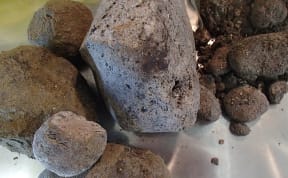
Work is being to determine if this pumice came from a volcano on the Kermadac Arc, and if it might have washed ashore during a tsunami about 2000 years ago. Photo: RNZ / Alison Ballance
Also up for analysis is some mysterious pumice. There are several layers of pumice, up to 20-centimetres thick, containing pieces ranging from 3-millimetres to 30-centimetres in size. Bruce and his colleagues say the pieces are nothing like pumice from the Taupo eruption, and that at the moment “the idea is that they are from the Kermadec [volcanoes]. It’s older than 2000 years, because it’s inland from the Taupo pumice shoreline which is about 1800 years old, and my guess is its going to be around 3000 years – although we’ll have to wait and see.” There is another well-known layer of pumice, that originated about 600 years ago from the Keramdec Arc and is known as Loisels pumice, and is found on the east coasts of the North and South islands, but Bruce says while the new pumice shares some of its characteristics it is not exactly the same. The new pumice is currently being cut into thin sections at Victoria University and Bruce is hopeful that close analysis of the pumice might reveal more information about its source. Meanwhile, the information about sand grains and diatoms might also help decipher whether the pumice was washed ashore during a large tsunami event.

