
For their 2015 conference, the Geoscience Society of New Zealand chose the theme Zealandia in Space and Time, to explore many aspects of how our planet works. From natural hazards to natural resources, and from plate tectonics to climate, geologists are uncovering the stories hidden in rocks.
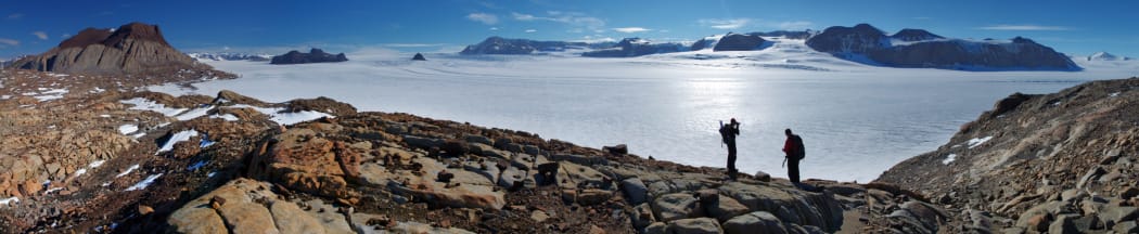
The view of Mt Suess and the Mackay Glacier from Gondola Ridge. Photo: Richard Jones
One of the highlights was research that reveals that Antarctic glaciers have retreated rapidly in the past, and that all it took was a minor climate warming.
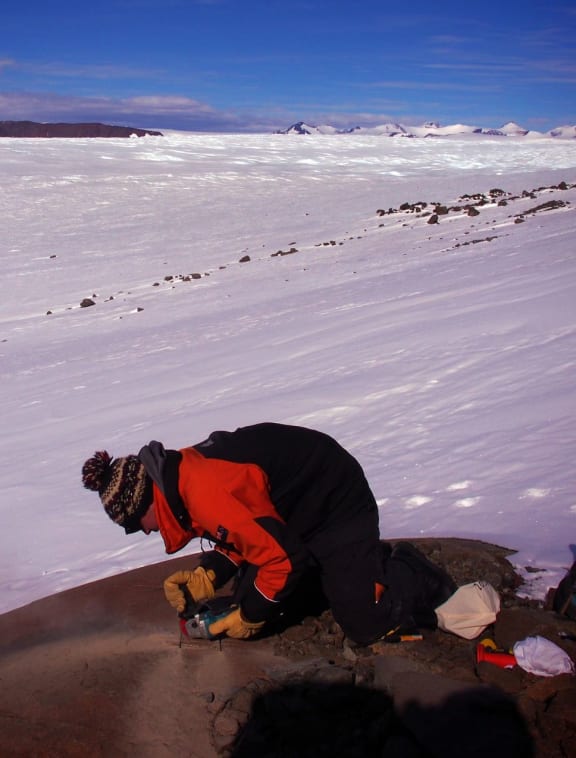
The chemistry on the surface of rocks changes when they emerge from the ice and are exposed to cosmic radiation. Here, Richard Jones is cutting samples from exposed rocks to investigate the thinning history of the glacier. Photo: Chris Fogwill
A team led by Richard Jones, a postdoctoral research fellow at Victoria University, collected and analysed rocks from different elevations along the Mackay Glacier, which drains the massive East Antarctic Ice Sheet (EAIS).
The EAIS has long been thought more stable than the West Antarctic Ice Sheet, where the melting of several glaciers has now reached the point of no return, according to a NASA study published last year. This research adds evidence that the EAIS is not a sleeping giant, but has in the past responded quickly to warming.
The chemical analysis of the rocks the team collected shows the Mackay Glacier retreated and thinned rapidly about 7000 years ago, and the retreat continued for several centuries.
Richard Jones says the rate of retreat was similar to that seen today in glaciers in West Antarctica, where satellite observations show the ice sheet is thinning in response to a warming ocean, and losing more than 150 cubic kilometres of ice each year.
Quite a few of the outlet glaciers of the Antarctic ice sheet are thinning rapidly and are theorised to undergo massive changes in ice loss.
Andrew Mackintosh, who is part of the research team, says the results provide the first geological evidence for the potential of runaway ice loss in Antarctica, triggered by what scientists describe as marine ice sheet instability.
Before Richard’s study, we had theory about how ice sheets might respond and we had computer models that encapsulate this theory, but we had no direct geological evidence that this had occurred in the past.
You can read the full story here or listen to the interview:
First woman to win McKay Hammer
During the conference, the Geoscience Society awards several prizes, including the McKay Hammer for the best publication.
This year’s winner is University of Auckland structural geologist Julie Rowland, better known among colleagues as JR, who is the first woman to win the award in its 59-year history.
The paper she received the award for is the result of research in which she investigated active geothermal areas in the Taupo area to use them as analogues for the deposition of gold in areas such as the Coromandel.
In the Taupo Volcanic Zone we have water that could be 250 degrees Celsius, coming up from depth, and when it’s hot like that it carries with it solutes or dissolved metals and other bits and pieces. And as that water comes up from depth, maybe 6 km down, it cools, its pressure changes, and it may, if the circumstances are right, drop out gold and silver.
She says her overarching interest is in broken rocks.
“I like to understand rocks and how they break under some sort of tectonic forcing. What I really want to get at is how the fluid that I might be interested in – it could be hot water carrying gold, but it could be molten rock or magma – how it moves through the crust, either for the purpose of making a geothermal energy recourse, or a gold deposit, or some sort of hazards application."
Understanding earthquake hazards
Many presentations at the conference focused on earthquake hazards. NIWA marine geologist Phil Barnes presented new insights into the tectonic landscapes of North Canterbury and the structural context of the Canterbury earthquakes.
He says the Canterbury earthquake sequence ignited an extensive geoscience response, focused on charting the crustal structure of north Canterbury.
The active faults in that area are hiding under the Canterbury Plains, so we have to use remote sensing techniques like looking at interpretations of gravity or seismic reflection data. This allows us to look at the structure and faulting of the rocks beneath the Canterbury Plains.
He says the Canterbury earthquakes happened at the further edge of the plate boundary zone in the South Island, a wide faulting zone that extends from Westland to Canterbury and is characterised by what geologists call crustal shortening, “where the region is undergoing compression in a north-west orientation”
“The result of that is that for the last million or two years the north Canterbury region has experienced faults that have become active again in an area where there were very old faults in the basement rocks already. The development of new faults and reactivated faults trough the north Canterbury area led to quite a wide spectrum of active faulting that we now see hidden away under the seafloor and the Canterbury Plains themselves."
Studying rocks under the sea
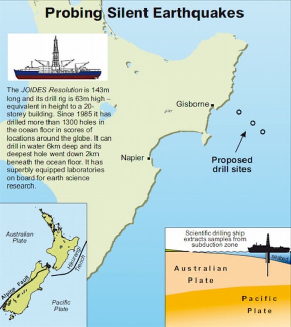
Photo: GNS Science
New Zealand geoscientists are part of the international Ocean Discovery Programme, a major global initiative to explore earth below the sea and to study the history and dynamics of our planet.
GNS Science geologist Stuart Henrys explains how New Zealand will contribute by investigating silent earthquakes under the seafloor east of Gisborne when the ocean drilling ship Joides Resolution arrives in our waters in 2018.
The expedition is expected to last two months, and it will be the first undersea drilling project anywhere in the world aimed specifically at understanding the mechanisms of slow-slip quakes.
Three drill sites up to 1.5km deep are planned: one on the subducting Pacific Plate, another where the plate boundary surfaces at the seafloor, and a third on the overriding plate directly above the area of slow-slip, about 40km east of Gisborne.
Stuart Henrys says silent earthquakes, also known as slow-slip events, are similar to an earthquake in that they involve more rapid than normal movement between two pieces of the earth’s crust along a fault line.
However, in a normal earthquake the slip occurs in a matter of seconds, suddenly releasing seismic energy, whereas slip in a silent earthquake can take weeks or even months to occur.

