
Tropical winds will produce abnormally mild weather over much of the country this weekend, forecasters say.
The National Institute of Water and Atmospheric Research (NIWA) said winds from north of Vanuatu would stream south, lifting temperatures to levels more akin to those of late-spring than mid-winter.
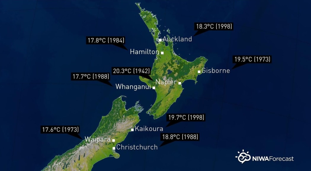
Photo: NIWA
It said areas from mid-Canterbury to the Far North would be affected, and daily temperature records might be broken.
While all-time monthly records were unlikely to be broken, daily records might be broken on Saturday when maximums were forecast to be anywhere from 5°C to 7°C warmer than average.
Several places might also have their mildest 23 July overnight on record, particularly across the North Island, NIWA said.
As air blows off the Southern Alps and ranges of the central North Island into the lower terrain to the east, it would warm considerably, the institute said.
Heavy rain was also forecast and severe thunderstorms might cause damage across the west of the South Island on Saturday and west and north of the North Island on Saturday night.
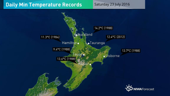
Photo: NIWA
Rainfall might range from 75mm to 150mm across the west of the South Island and 50mm to 100mm across the west of the North Island.
Wind gusts in excess of 150km/h were possible in the west of the South Island, across the Cook Strait and Wellington, and for much of the western and central North Island later Saturday through to early Sunday, NIWA forecast.
On Sunday, showers and strong, gusty winds would continue across the west of both Islands with snow for the ski fields of the South Island.
Through the end of July, mild periods, especially for the east of the South Island and the North Island, would alternate with cool ones.
NIWA was picking a "more impressive cool snap" for the start of August.

