Flash flooding is possible in Auckland today as the remnants of ex-cyclone Debbie hit the North Island, MetService says.
Moist looking picture of the North Island this evening https://t.co/Yjbq0jxdqz ^PL pic.twitter.com/xLGd6P6OLB
— MetService (@MetService) April 3, 2017
Heavy rain and flooding has been forecast for this week as the warm, moist air descends on New Zealand.
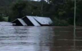
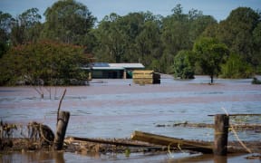
The cyclone lashed northern Queensland last week, and its tail has brought massive flooding to that state as well as New South Wales, killing three people - with more feared to be dead - flooding thousands of homes and sparking mass evacuations.
NIWA said the "tropical torrent" could bring two to three times the amount of normal rainfall for the entire month of April in just a couple of days.
MetService severe weather forecaster Erick Brenstrum told Morning Report there was a risk of flash flooding in Auckland today.
Mr Brenstrum said there could be thunderstorms over the upper North Island with 40mm an hour of rain possible in Auckland.
Severe weather warnings were in place for Taranaki, Whanganui, Hawke's Bay, the Tararua Range and Wairarapa.
Rainfall totals in some areas could exceed 200mm and people were being warned to watch out for rapidly rising rivers and streams, surface flooding and slips.
And heavy rain was also expected in the central North Island from Waitomo right through to Gisborne, Coromandel, Rotorua and Bay of Plenty from this morning.
There's already been 50-70mm of rain recorded by many stations across central NZ in past 12 hrs. More coming https://t.co/Yjbq0jxdqz ^PL pic.twitter.com/SZvbCL4d0m
— MetService (@MetService) April 3, 2017
The Fire Service said it has received reports of surface flooding in Manawatu and New Plymouth.
The Transport Agency has urged drivers to take care on roads and the Education Ministry has urged parents to check with school and early childhood centres in case of closures due to the weather.
Many parts of the country have already had a wet end to summer with record rainfall and flooding in the north of the North Island, Auckland and Coromandel earlier this month.
MetService duty forecaster Raveen Das said the heaviest falls overnight were in inland Whanganui.
Mr Das said some places have recorded 50mm of rain over the last 12 hours but he expected the rain to get heavier today.
The deep low moving in from the Tasman would bring continuous rain to much of the country today and tomorrow, Mr Das said.
Rather than a short, sharp storm, this one would be more gradual, he said.
Horizons Regional Council said it was monitoring river levels and there was a possibility floodgates would need to be opened this afternoon.
Operators were on standby and it said farmers who used the spillway land would be notified as soon as possible.
Mr Brenstrum said later tomorrow a cold front was set to sweep over the North Island with thunderstorms and winds ahead of it.
And a new low would cross east over the upper South Island overnight Wednesday and spread heavy rain down into Kaikōura, Canterbury and Otago.