Record rainfalls have been recorded in parts of Otago and Canterbury, prompting states of emergency to be declared in Timaru, Otago and Dunedin. Here's what you need to know:
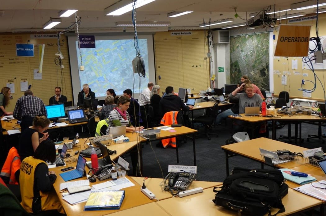
The Emergency Operations centre has been activated in Dunedin. Photo: RNZ / Ian Telfer
About 10.25pm, Dunedin Civil Defence told 50 households in Henley and Mosgiel to evacuate immediately. The controller Sue Bidrose said the Taieri River was rising rapidly. She said all residents in Henley township, the Upper Taieri ponding area and the Gordon Road spillway area should leave their homes.
Anyone who needs a place to stay should go to the Civil Defence information centre in Mosgiel in Cargill Street. Anyone who needs help to evacuate should call Civil Defence.
A state of emergency has been declared in Dunedin with sandbags available at:
- South Dunedin - carpark behind St Clair Tennis Club, Victoria Road
- Mosgiel - Memorial Park car park beside the stadium/Mosgiel Memorial Gymnasium
A state of emergency has also been declared in Otago.
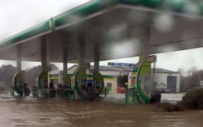
Residents have been evacuated from Wallbrook Crescent in Oamaru. There is surface flooding on many of the streets in town with two bridges underwater.
Waitaki District Council had used up all its sandbags and arrangements were being made to see if extra bags from Dunedin could be shifted there.
A state of emergency has been declared in Timaru due to the risk of rising rivers pushing more water into flooded areas.
The Timaru District Council said river levels were expected to rise significantly over the next few hours.
It said anyone in flood prone areas should prepare for evacuation at short notice.
NIWA said in the past eight hours, Timaru has recorded more rain than it typically received in the entire month of July.
A Public Information Map, with live feeds from NZTA:
Floodwaters are also threatening homes in Ashburton, Rakaia, Methven and St Andrews.
State Highways closed
There are numerous local road closures in Dunedin, and North and South Canterbury and Masterton.
The Transport Agency says drivers should avoid State Highway 1 between Christchurch and Oamaru as flooding has made many parts of the road near impassable.
A spokesperson says conditions are now treacherous and roads may close at short notice.
The agency said people travelling between Christchurch and Picton are advised to allow extra time due to school holiday traffic and road works on this route.
Snow and ice are possible again on the major alpine mountain passes.
In Queenstown flights in and out of the airport have been cancelled this afternoon due to strong cross winds.
An airport spokesperson said as of this afternoon there was no seat capacity for people to rebook until Monday.
Dunedin Airport has also cancelled several flights because of what it describes as "extreme weather".
North Island
- SH3 - Manawatu Gorge - slip
- SH4 - Papaiti to Raetihi - slip
South Island
Authorities are urging drivers to delay journeys south of Christchurch or north of Dunedin today, with significant flooding on State Highway 1 from Timaru to Dunedin.
The highway is also closed by flooding near Waimate.
- Inland Route 70 from Waiau to turnoff near Kaikoura - slips and rockfalls
- SH77 Ashburton to Methven - flooding
- SH79 Fairlie To Geraldine - flooding
- SH82 Waimate To Kurow
- SH83 Peebles To Pukeuri
NZTA says motorists should delay travel on SH1 in South Canterbury as "significant flooding" is expected to cause long delays.

The centre of the low can be seen near Banks Peninsula around 2.30pm. Photo: https://earth.nullschool.net/