More than 2500 lightning strikes have been recorded today as storms covered most of the central North Island.
MetService forecaster Allister Gorman said heavy rain was hitting Manawatu and Hanmer Springs, but had eased in the Waikato.
The heaviest rainfall recorded by MetService was 55mm at Flat Hills, between Hunterville and Maungaweka. It had 30mm fall within an hour, between 3.30pm and 4.30pm.
Mr Gorman said the weather would quieten overnight but thunderstorms were possible tomorrow in Taranaki, eastern Otago and the top of the South Island.
Thunderstorms were also causing heavy rain in Kaingaroa forest east of Taupō, and in Masterton.
Ranges near Gisborne had 24mm of rain between 2pm and 3pm.
A severe thunderstorm warning has been issued from today for inland areas of the North Island.
MetService forecaster Allister Gorman said thunderstorms were hitting Waikato, Waitomo, southern Taihape, and northern Manawatu.
They were also in west Auckland and in the ranges of Gisborne and Hawke's Bay.
Our webcam at Masterton airport has caught a great shot of a thundery shower engulfing the Tararua range to the west this afternoon ^AC pic.twitter.com/ZLuEdgUv2U
— MetService (@MetService) January 2, 2018
MetService forecastor John Crouch said thunderstorms are likely to develop in many areas from Auckland, through the central high country and down to Wairarapa today.
Convective showers are already bubbling up over Auckland - expect a few of these to 'supercharge' into thunderstorm cells around midday. You can keep an eye on their progression by looking out the window and on the rain radar https://t.co/7k3nmdWQwx ^AC pic.twitter.com/bf8qQV8jPT
— MetService (@MetService) January 1, 2018
He said some of those will be slow moving, and cause downpours.
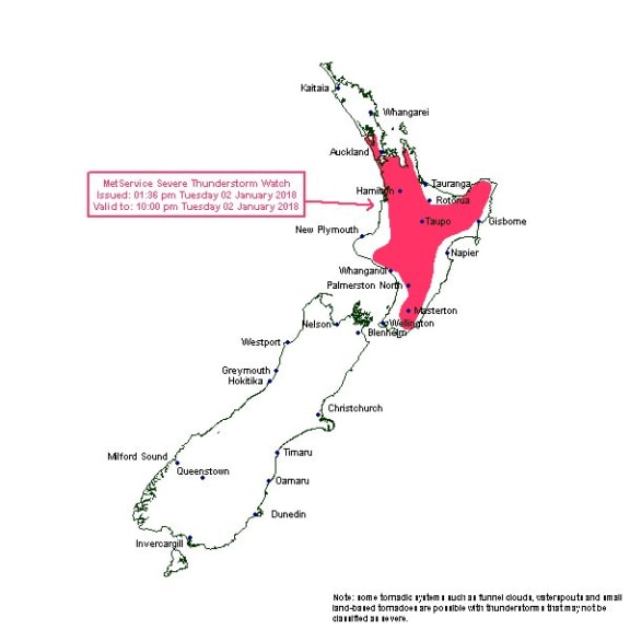
Severe Thunderstorm Watch Photo: MetService
Downpours of up to 50mm/h are possible and heavy showers could cause surface flooding, flash flooding and slips.
Driving conditions will also be hazardous with surface flooding and poor visibility in heavy rain.
Further areas over the South Island are also under a thunderstorm risk today with inland ranges of Marlborough and Nelson Lakes the most likely to see lightning or heavy showers.
MetService Meteorologist April Clark yesterday said the second half of this week is looking wet for the North Island.
"A dynamic low is expected to form to the west of the Island on Thursday. This is likely to bring heavy rain and strong or gale northeasterly winds to northern regions including Bay of Plenty."
She added there is some uncertainty of the exact path of the low from Friday onward, but there is potential for persistent rain to spread as far south as Christchurch by Saturday.
Main centre forecasts today
Whangarei
Fine spells. One or two showers this afternoon then becoming cloudy and windy in the evening. Will reach a high of 27C.
Auckland
Partly cloudy. Showers from the afternoon with heavy thunderstorms and winds. Will reach a high of 25C.
Hamilton
Cloudy with showers and a chance of heavy thunderstorms and light winds. Will reach a high of 24C.
Tauranga
Mostly cloudy with a few showers and northerlies developing this afternoon and a high of 23C.
Wellington
Fine spells with northerlies and a high of 24C.
Christchurch
Fine spells increasing with cloud returning in the evening and northeast breezes. Will reach a high of 26C.
Dunedin
Fine apart from cloud in the evening and light winds. Will reach a high of 22C.