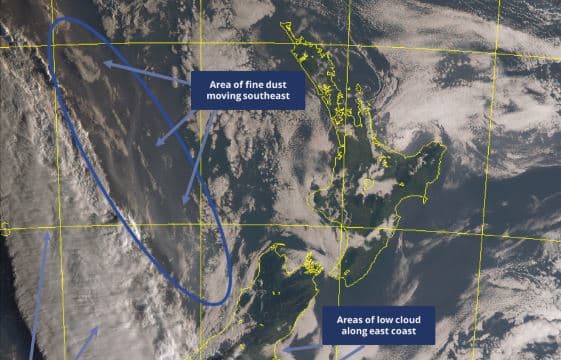
A dust cloud that has caused air quality problems in parts of Australia is expected to hit New Zealand today.
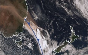
A MetService satellite image showing the dust cloud. Photo: MetService
MetService meteorologist Andy Best said the dust could be clearly seen on satellite imagery as it moved towards New Zealand.
Places between Hokitika and Farewell Spit could notice fine, brown dust in the air this evening.
Northwest winds could move fine dust into areas from South Taranaki to Wellington from this evening, so enhanced sunsets and sunrises might be seen in these areas.
The broad area of dust from Queensland was picked up by strong northwesterly winds just ahead of a cold front, that is currently over Fiordland, Mr Best said.
MetService is predicting slightly cooler temperatures across the country over the weekend, but no significant rainfall is expected.
A cold front is moving up the South Island today, bringing a cooler southerly change.
Although the West Coast of the South Island will see rain or drizzle today, it is expected to be confined to the front.
By the time the front crosses the North Island, it will only bring a few showers, offering little respite from the dry conditions experienced across New Zealand.
"A new broad ridge of high pressure takes charge over the entire country on Sunday, bringing mostly fine weather, and the dry conditions are set to continue across the country through Monday," Mr Best said.
MetService forecasters are monitoring Tropical Cyclone Oma, which is currently a Category 2 cyclone, located west-northwest of Vanuatu. It is expected to track southeast towards New Caledonia.