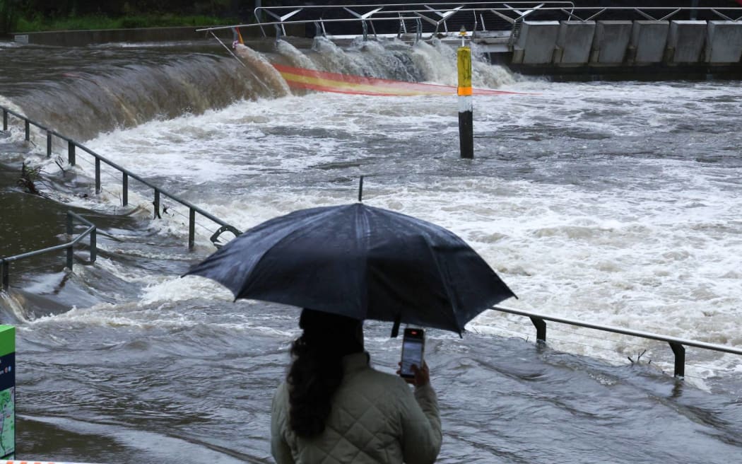
A woman takes pictures of the overflowing Parramatta river at the ferry wharf in Sydney on 5 April, 2024, after heavy rain lashed eastern Australia, causing flash flooding and a string of emergency warnings up and down the Pacific coast. Photo: Saeed KHAN / AFP
Australian authorities on Saturday said 152 people had been rescued from floodwaters in the eastern state of New South Wales after torrential rains sparked warnings for residents to move to higher ground.
Authorities said 72 rescues were carried out in state capital Sydney, Australia's largest city, where there was dangerous flooding in several low-lying suburbs.
Some 15 emergency evacuation orders were in place statewide, said New South Wales State Emergency Service, which had fielded 4128 calls for help in the 24 hours to 5am (local time).
"Flood levels in some of the rivers particularly in western Sydney are continuing to rise," New South Wales Premier Chris Minns said in a televised media conference.
Torrential rains pummelled Australia's southeast on Friday, dumping almost a month's worth of rainfall on Sydney and prompting warnings for people to avoid non-essential travel and stay indoors.
Sydney received 111 mm of rainfall over the 24 hours to Friday morning, data from the nation's weather forecaster showed, just shy of mean rainfall of 121.5 mm for the month of April.
Rainfall records broken
Earlier, an overnight deluge dumped heavy rain across parts of Sydney and the Illawarra, prompting emergency evacuation warnings and rapid river rises.
The torrential falls are part of a broader rain event soaking eastern Australia, which has triggered more than 50 flood watches and warnings from southern Queensland to the NSW south coast.
Bellambi Point, north of Wollongong, has received 190 millimetres of rains since 9am Friday - with 35mm falling in the half hour to 6.10am.
Evacuation orders have been issued for Sydney's north, specifically for residents living close to the Narrabeen Lagoon and Manly Dam.
Residents in Warriewood, North Narrabeen, the Narrabeen Peninsula have been told to leave immediately due to dangerous flooding.
People in central Picton, southwest of Sydney, have also been told to evacuate due to expected flooding.
In Greater Sydney, the biggest falls have been experienced in Penrith, where 167 millimetres was recorded, and Terrey Hills and Canterbury, which have received more than 150mm since 9am yesterday, with the biggest falls coming overnight.
Gosford in the Central Coast has been soaked with 161mm.
Multiple rainfall records have been broken by the deluge, including:
- Penrith - 167mm - heaviest rainfall on record (weather station opened in 1995)
- Bellambi - 195mm - heaviest rain in six years.
- Chatswood - 189mm - heaviest in four years. Chatswood was also the wettest Sydney suburb.
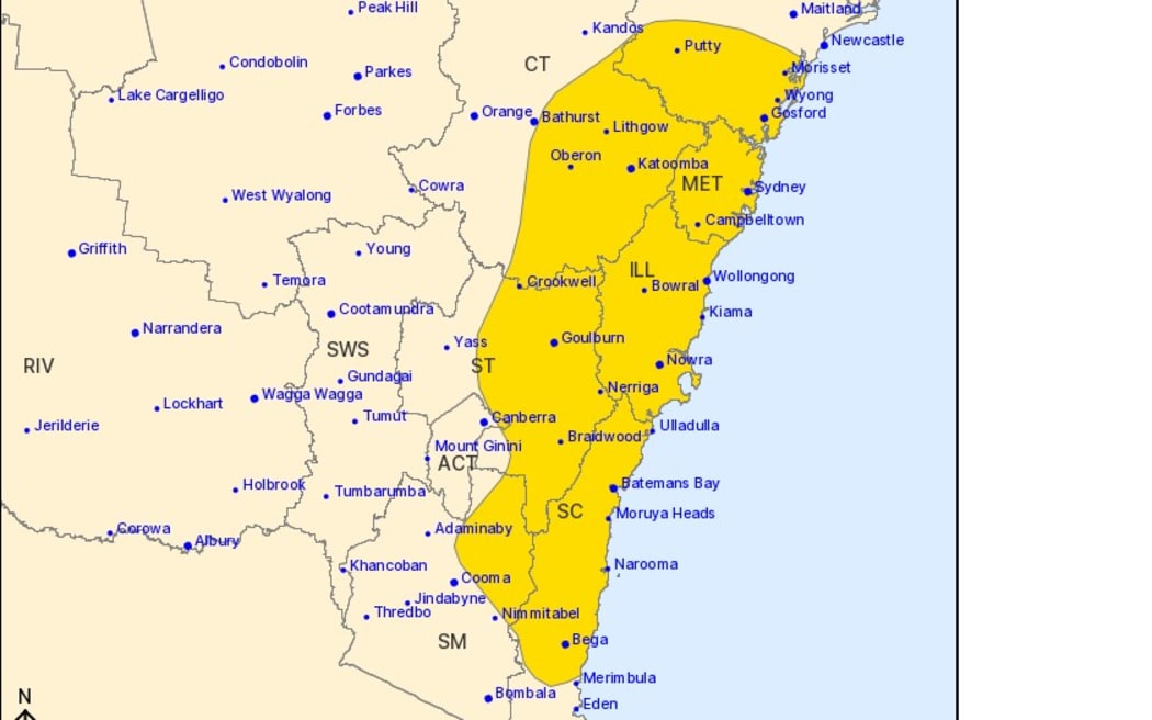
Photo: Bureau of Meteorology / Supplied
After bringing falls in excess of 100mm to southern Queensland and the NSW Northern Rivers on Thursday, the heaviest falls drifted south on Friday morning to the Mid North Coast.
Taree and Port Macquarie were both drenched by more than 100mm by the evening - about a months' worth of rain - with those totals now about 130mm since 9am Friday.
The rainfall and inflows from days of wet weather to the Hawkesbury River overnight have prompted several low-lying communities to be told to prepare for evacuation.
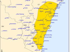
The Bureau of Meteorology (BOM) has issued a string of flood and extreme weather alerts.
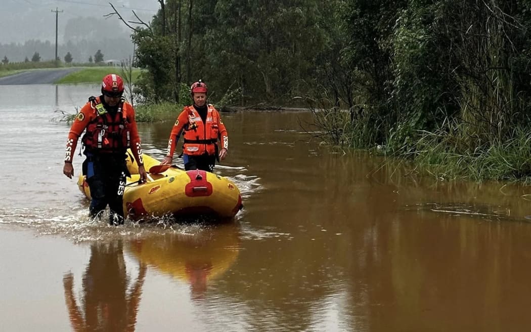
Photo: NSW SES
There was a warning very dangerous thunderstorms were likely to produce intense rainfall that may lead to dangerous and life-threatening flash flooding throughout Saturday morning across Sydney, Parramatta, Wollongong, Bowral, Campbelltown and Port Kembla.
"The widespread severe weather risk is forecast to clear south of the Hunter and Sydney Metropolitan areas by sunrise on Saturday, the Illawarra by late Saturday morning and the South Coast by Saturday afternoon," the BOM said.
Warragamba Dam has reached full capacity and began spilling at 5:45am, Water NSW said.
BOM meteorologist Helen Reid said there had been at least 100 millimetres of rainfall across every inch of Greater Sydney.
"We saw widespread, very heavy rain, locally intense rains, a lot of rain," she said.
Despite the rain clearing, Ms Reid said residents still needed to be "mindful of the flood warnings associated with the rainfall that's already in the landscape".
Highways closed by floodwaters
Some major roads in Sydney and the Illawarra have been closed due to flooding.
In Sydney's south, the Princes Highway is closed northbound at Engadine, and Bexley Road is closed in both directions at Bexley North.
The Illawarra Highway is closed in both directions between Tongarra Road and the M1 at Albion Park, and also at Macquarie Pass.
Motorists have been advised to avoid non-essential travel and not to drive through floodwaters.
A woman had died following a head-on collision in wet conditions in the NSW Central West on Friday afternoon.
Emergency services were called to the Castlereagh Highway south of Mudgee just after 2pm following the crash between a ute and an SUV.
A 32-year-old woman was taken to the Mudgee hospital in a critical condition but died a short time later.
Five other people were taken to hospitals across the state following the crash including two young girls aged two and six.
Damaging easterly winds averaging gusts up to 70 kilometres per hour and peak gusts of about 90kph were possible in the South West Slopes including coastal parts of the Sydney metropolitan area.
Winds of up to 125kph were likely for alpine areas, the BOM said.
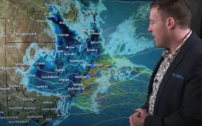
Here's what to expect across Australia over the weekend, including the rain, flooding and storms in the east & the hot and dry weather in #WA.
— Bureau of Meteorology, Australia (@BOM_au) April 5, 2024
Video current as of 2:30 pm AEDT, Friday 5 April 2024. Latest: https://t.co/4W35o8iFmh pic.twitter.com/NCMLt0hIbX
Residents on alert as Hawkesbury River rises
New South Wales State Emergency Service has issued several warnings and evacuation alerts for river systems of the Western Sydney and Illawarra regions.
After consistent, heavy rain overnight, the BOM said the Hawkesbury River at Windsor was likely to exceed the moderate flood level of 7 metres this morning.
An evacuation order was in place for residents in the Gronos Point area north of Windsor.
People living in low-lying farmland at Agnes Banks, south of Richmond, had been ordered by the SES to evacuate by 7am, along with residents of the Riverside Caravan Park in Cattai.
An evacuation centre had been set up at Richmond Club.
Residents at Cornwallis and the eastern part of Richmond Lowlands, and parts of Lower Portland on the eastern side of the Hawkesbury River, had been told to evacuate by 8am.
There was also a watch and act alert for low-lying areas of the Colo River.
Major flooding of up to 12 metres was also likely early on Saturday morning at the Upper Nepean River, and was expected to reach minor levels at Menangle Bridge, Camden and Wallacia Weirs.
SES on alert for 'volatile' conditions
NSW SES spokesperson Andrew Edmunds said preparations were in place to respond to the intense wet weather affecting the Hawkesbury and Nepean region.
"We're expecting significant rises on the Hawkesbury, Nepean today and have flood rescues teams, aviation assets and high-clearance vehicles pre-positioned and ready to respond to any incidents," he said.
"We're expecting a numbers of road closures as a result of flood water and also some key bridges to close due to floodwaters."
Evacuation centres had been set up in parts of Greater Sydney including Bankstown, Liverpool and Richmond.
Mr Edmunds cautioned the state's residents to make responsible decisions and follow the advice of emergency services.
The rain across Sydney slowly increased through Friday and by sunset Observatory Hill had already collected more than 160mm for the event, the wettest 48 hours in four years, although even heavier rain arrived overnight.
The band of torrential falls was heading south down the coast and should clear from Sydney by mid-morning, before contracting to the South Coast by the afternoon where it should ease by tonight.
The deep trough responsible for the deluge had also strengthened winds and whipped up huge waves, already peaking up to seven metres off the coast of Sydney on Friday evening.
While showers and storms would continue for parts of the state on Sunday, no further widespread heavy rain was likely.
- ABC with Reuters