Westport residents have had their first opportunity to question experts about a potentially ground-breaking business case to ease severe flooding in the town over the next hundred years.
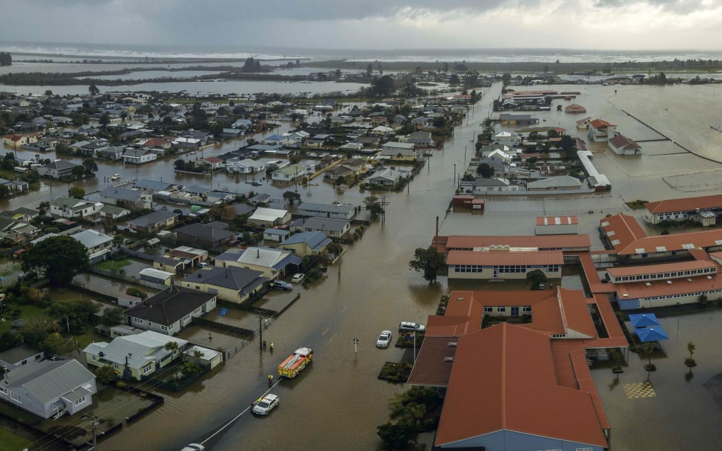
Buller High School and surrounds in Westport following flooding on 17 July 2021. Photo: Supplied/NZ Defence Force
An information evening was held in the town on 10 August to brief residents on the $54 million case put to the government by Buller District Council, West Coast Regional Council and Te Rūnanga o Ngāti Waewae.
If approved, it could set the bar for future community climate change packages, with the government asked to pay $45m of the total bill.
The message to Westport was simple, laid out clearly by Chair of the Buller Recovery Steering Group Richard Kempthorne.
"It can't protect every bit of Westport because it's simply not feasible nor affordable.
"It's unlikely that we'll be able to build our way out of this forever. But what we are looking at doing is saying what can be done and what should be done," he said.
Locals had plenty of questions - they are worried about coastal and river flooding, blocked and old drains, debris build up, erosion and stopbanks.
Some wanted to know why the plan differed from the original one they were shown and why the stopbanks would no longer protect their properties.
"This morning we talked about adaptation, we talked about compensation. So I've got a housing development up there [near Nine Mile]. And it was originally planned for 73 units. Given your alignment of the wall now, we're down to 45," one disgruntled resident explained.
River modelling expert Matt Gardner said the design had been altered to protect from a flood of a scale that had never been seen before.
"The event which we're designing for is significantly larger than what occurred in July 2021. And when you do the modelling, it actually shows that that embankment does overtop in a climate change scenario so it's nothing that we've seen before because we're designing for a future climate," he said.
But it was still subject to change, Gardner added.
It was the state of stormwater drains that had others incensed.
"You can build as many walls as you like and you can go as high as you like. But if the stormwater is not fixed, 50 percent of Westport will go underwater again, like it did in the last floods.
"I live on the Esplanade. We got flooded [but] not by the Buller River - by what came up the culvert pipes," one resident explained.
Another said the pipes at her place even flooded a little during a high tide.
"Water was coming up out of the drain and onto my property. Because it's an early 19th century house and the road has been built up and up and up, it's kind of like a big hill outside my house, and all the stormwater just comes onto my property. Is anything going to be done about the drains?" she wondered.
River engineer expert Gary Williams assured them $12m from the plan had been put aside just for stormwater management, and included the construction of new pump stations.
"We are going to look at all the outlets that are underneath or around where the ring bank is. So they're all going to have valves and floodgates on them, but they don't have them at the moment," he said.
Business case lead and consultant John Hutchings acknowledged there was still a lot of work ahead yet to get the details right.
"[On] the table when we negotiate with central government [will be] the number of landowners, how it aligns with property boundaries, to ensure farm operations are fully able to be carried out, the constructability, ease of access getting to the sight, the consent ability," he listed.
A Cabinet decision on the business case is expected before the end of October.