Wellington mayor Andy Foster says actions are already being taken to reduce the number of properties affected by sea level rise.
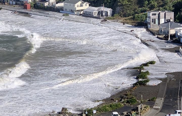
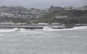
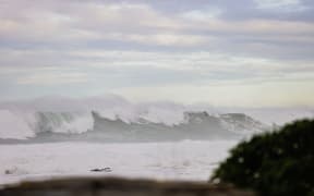
Massive waves which forced evacuations at Ōwhiro Bay on Wellington's south coast in April 2020. Photo: Supplied / Donna Drinkwater
The data shows the sea level is rising twice as fast as previously thought in some parts of Aotearoa, massively reducing the amount of time authorities have to respond.
Globally the sea level is expected to rise about half a metre by 2100 - but for large parts of New Zealand it could more than double that because of land subsidence.
The projections show infrastructure and homes in Auckland, Wellington and many other places risk inundation decades earlier than expected. In the capital, some areas will have a sea level rise of 30cm by 2040.
Foster said each area would need to be assessed.
"If we take it as the big picture, the options basically are we defend, or we retreat or we modify and the answer to that is going to be different for different places."
Some areas would be protected to the extent that they can be such as with sea walls, but in other areas that would not be economic.
Wellington's new district plan will notify people of natural hazards including sea level rise.
Anyone wanting to build in a "high risk" area would need to get a special non-complying consent and they were very hard to obtain, Foster said.
"But also the government's recent three houses per property would not apply in those areas and that's the areas that are subject to inundation so you wouldn't be able to intensify in those areas."
Someone could replace an existing house in those areas but would not be allowed to build a new one, Foster said.
Tasman District mayor Tim King said it would be interesting to compare the new data with information that his council had already collected.
"Clearly it's something that we've been aware of for a significant length of time, although this information is new the issues around some of the low lying parts of our district are not and we've been working for the last few years getting our own information including on things like the tectonic uplift and subsidence."
Nelson City Council already had plans in place to manage future sea level rise at Nelson Airport which is on the Waimea Estuary, King said.
They would also have to take account of this new information.
King said it would be necessary to work through the data to look at how it would affect individual locations to determine what it meant and then have a discussion with those communities.
It was unlikely councils would be able to meet the costs of dealing with issues relating to rising sea levels alone, he said.
"The costs are significant in relation to particularly infrastructure, whether it comes to moving airports or moving communities."
Lower Hutt is in a vulnerable position with predictions of 30 centimetres of sea level rise by 2040 - which will affect the waterfront road connecting Petone and Eastbourne.
Lower Hutt mayor Campbell Barry described the new data as "very sobering" saying it reinforced the need for urgent planning to look at how to support coastal communities.
There were up to 7000 residents near Petone and Eastbourne, he said.
"And we've got some major projects as well that this is the sort of information we need to factor in when we decide what we're going to invest in and how we're going to do those projects."
For example, the council was this year set to undertake work in Lower Hutt's eastern bays, Barry said.
"We need to make sure that we do it to a level that ensures that it is able to cater for this type of sea level rise, for increasing storm events which we know will occur and to allow for that infrastructure to be protected because that is a community where there is one way in and one way out."
'Ludicrous' council cannot stop people building in flood prone areas - Auckland councillor
Auckland councillor Richard Hills said it was ludicrous councils could not stop new homes being built on private land that will flood in next two decades due to rising sea levels.
Hills, who is chair of the Auckland Council's environment and climate change committee, said the new data was scary stuff.
"It does always freak me out but it doesn't surprise me. I guess that's what everything to do with climate change is currently doing in this country and globally. It's rushing further and faster than we all expected. But the scientists had been saying this for 30 or 40 years now."
If you looked at what had been happening in the last couple of years you could tell things were moving faster than expected, he said.
"You just have to look around that we've been having one in 100 year floods sort of every month all around the country."
Coastal inundation zoning told people they were putting themselves and their property at risk if they chose to build in that zone, he said.
But under the Resource Management Act the council could not stop people from building on private land.
"There's not a lot we can do to prevent builds in those coastal inundation zones right now."
Local government was still waiting for some guidance at a national level about how to address private property owners wanting to build in coastal inundation zones, Hills said.